By Jess Taylor –
Have you ever read a historical treatise and wished it was integrated into an interactive map, allowing you the ability to visualize the story geographically?
What if while reading about Hannibal crossing the Alps with his elephants you could simultaneously observe where the journey unfolds on a map? And be able to interact with the map where his famous battles of Trebia, Trasimene, Cannae and Zama took place?
When first reading the story of Hannibal, I too had this desire and decided to bridge the gap by creating Odyssey Maps, a data driven, map-based storytelling framework that integrates narrative with a modern, interactive, satellite-backed map.
About Hannibal Barca
Hannibal is best known for his audacious Alpine crossing with elephants and for his brilliance as a commander who hounded the ascendant Roman Republic.
Yet his journeys span over six decades, from his birth in Carthage to his death in Anatolia. In between lies a rich arc that begins in Carthage, centers on Iberia and Italy, returns to North Africa, and ends in the eastern Aegean.
Cities were founded, Iberian mineral wealth was exploited, battles were won and lost, and a long strategic chess match unfolded—pitting Hannibal, his brothers, and Carthage against Rome, its Senate, and its generals. So many places are traversed, across such vast geography, that the story demands cartographic support.
The Odyssey Maps Software Framework
The Odyssey Maps framework integrates narrative and mapping by breaking a story into passages, each linked to a map annotation. As readers advance through a passage, the map pans/zooms to the relevant place and remains fully interactive.
Stories progress in natural order (e.g., a journey timeline) or via direct access: readers can jump using the map or a table of contents.
Passages can expose supporting passages—contextual deep-dives that appear only when their parent passage is active—so detail arrives at the right moment without cluttering the map. Labels (place names), lines (routes / boundaries), and polygons (regions) can be layered to reinforce the narrative.
The framework is patent-pending and data-driven: the story data itself drives the UI, so any map-benefiting narrative can be published without additional coding.
Odyssey Maps works for general storytelling and for education across history, geography, and cartography.
An Example: Hannibal Barca – Rome’s Greatest Enemy
Journeys
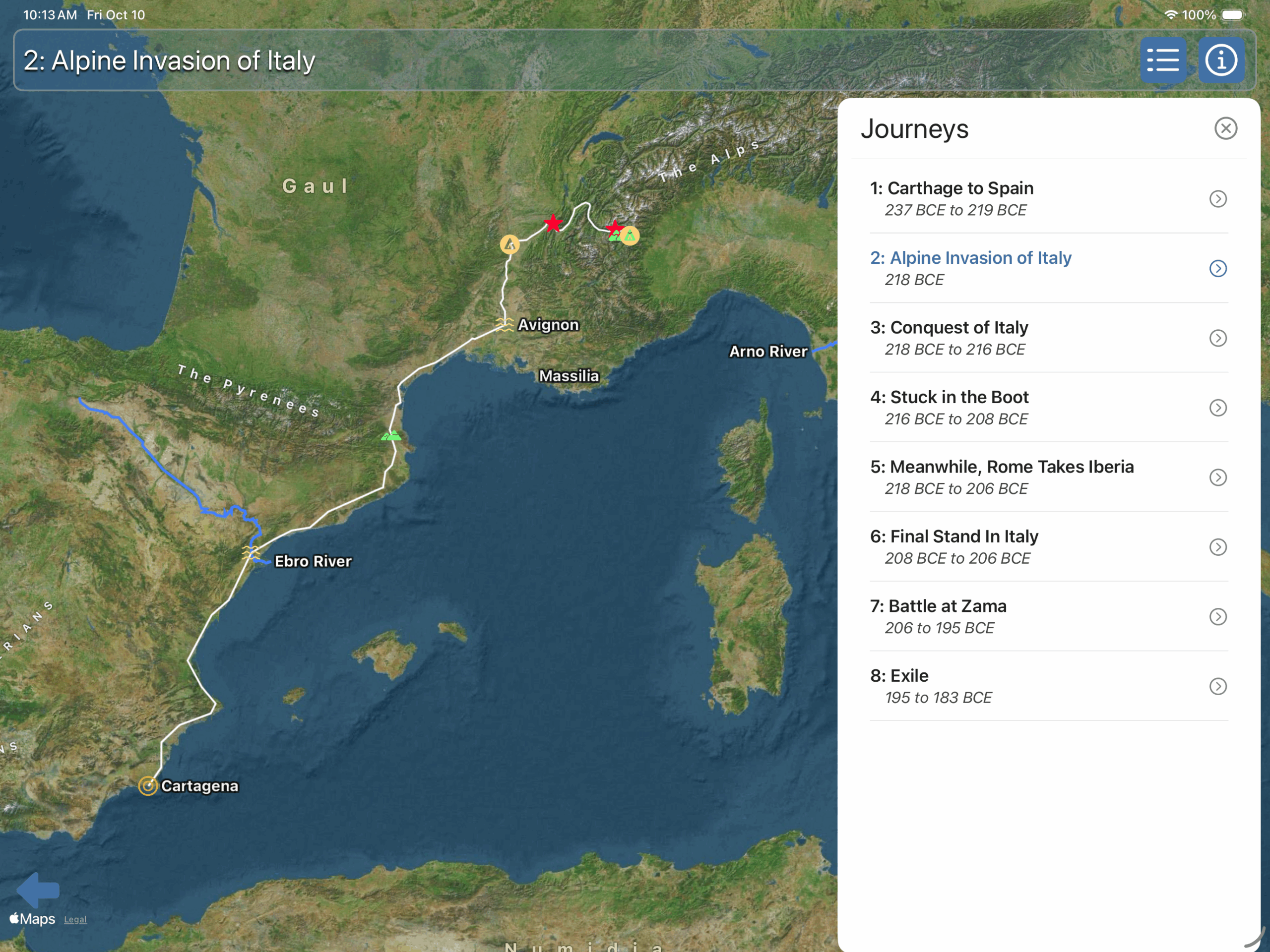
Hannibal’s six decade narrative is divided into 8 concise Journeys, each with multiple passages. Figure 1 presents the Table of Contents and the map for Journey 2: Alpine Invasion of Italy—9 passages starting at Cartagena (New Carthage), crossing Iberia, Gaul, and the Alps, and ending at a camp near Susa.
Journey Summary
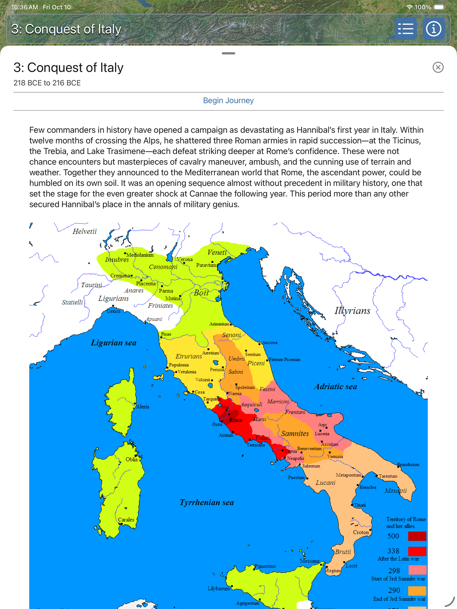
In addition to passages, each journey includes a summary. Figure 2a shows the map for Journey 3: Conquest of Italy alongside a portion of its summary. This journey departs from Camp Susa, where Hannibal’s army recovered after the Alpine crossing, and concludes 13 passages and roughly two years later at the Battle of Cannae in southern Italy. The full reading experience appears when you raise the scrollable text view to its fully expanded position (the summary view here), as shown in Figure 2b.

Passages
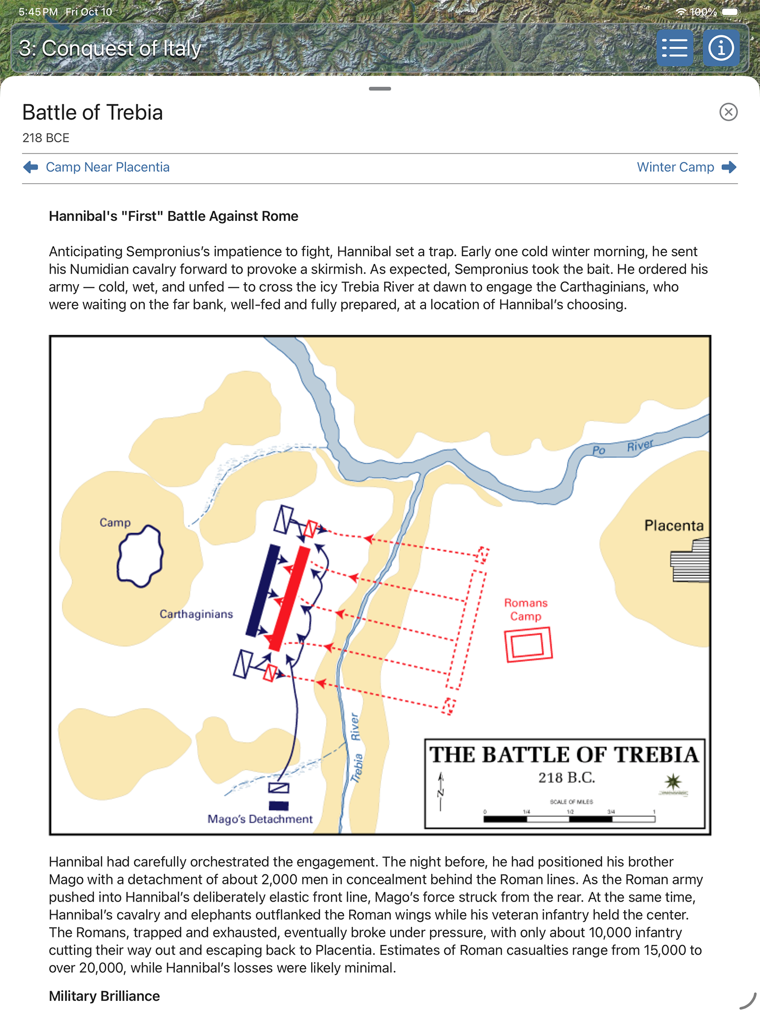
Each map position (annotation) is linked to a narrative passage (see Figure 3), here shown for the Battle of the Trebia in Journey 3: Conquest of Italy. Figure 3a shows the active position with its callout and a portion of the associated text panel. Figures 3b–3c show the scrollable text view raised for reading and scrolling. Passages can also include diagrams and images that deepen context—in this example, a battle diagram of Carthaginian and Roman lines of engagement and a contemporary winter photo of the icy Trebia River.
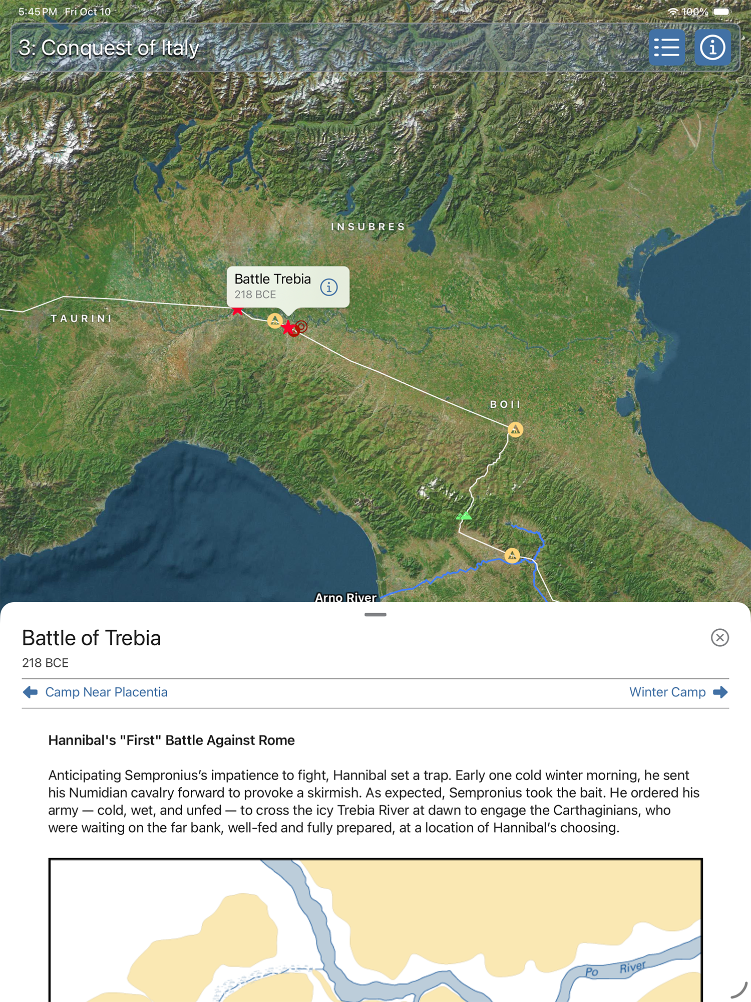
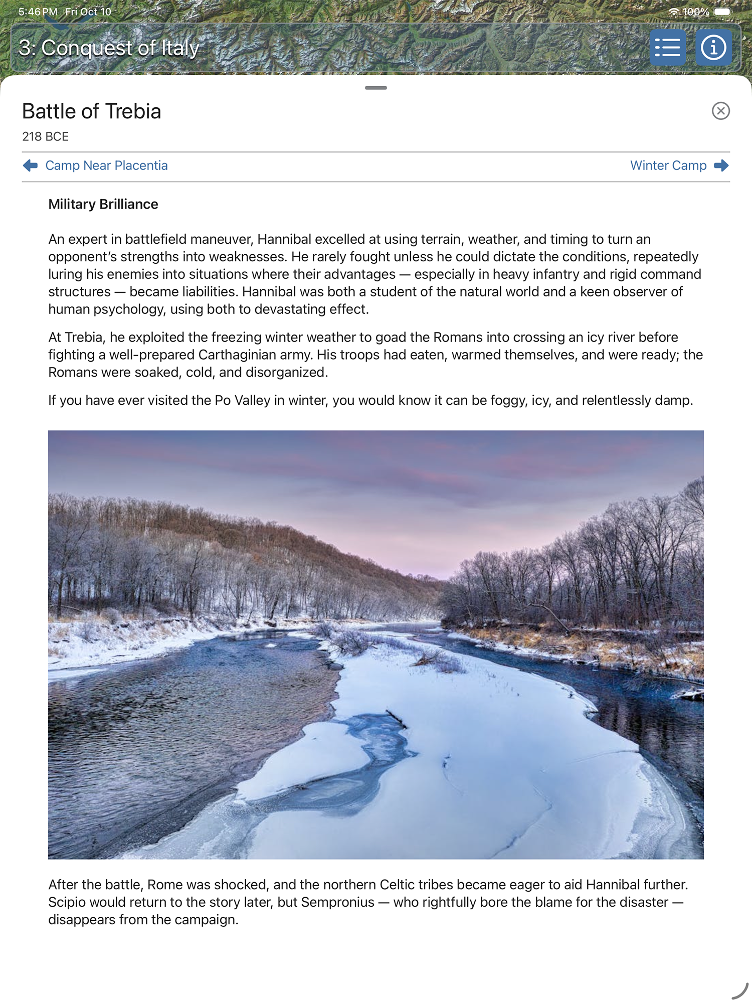
Navigation from passage to passage is available in the text view and—when the text view is fully dismissed—directly on the map. This tight integration of narrative and cartography makes the experience unique: at each step in the journey, the story is paired with a customized map that supports and clarifies the narrative.
If you prefer to explore non-linearly, you can also jump to any passage from the map or the table of contents—the curated journey is optional.
Supporting Passages
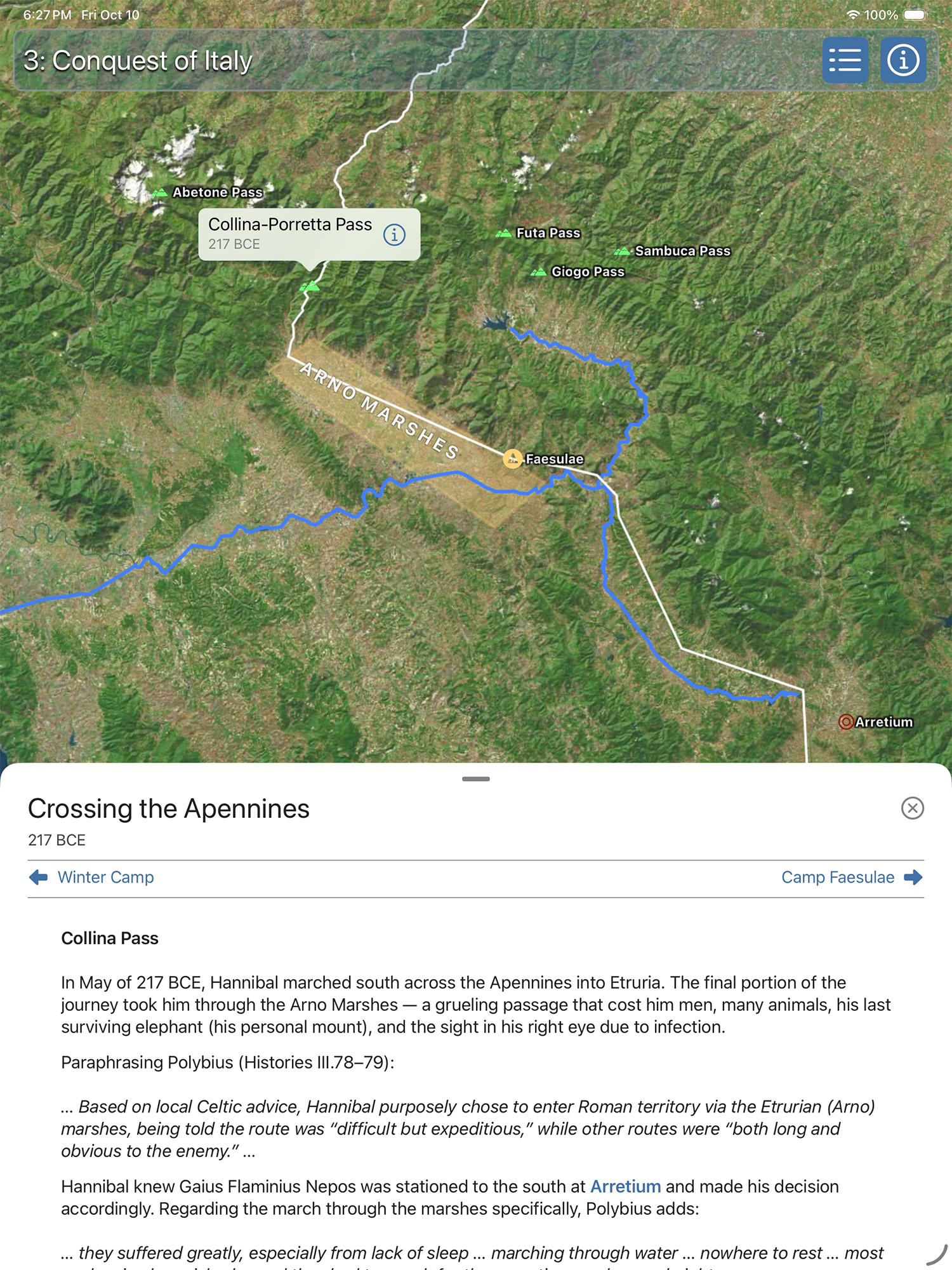
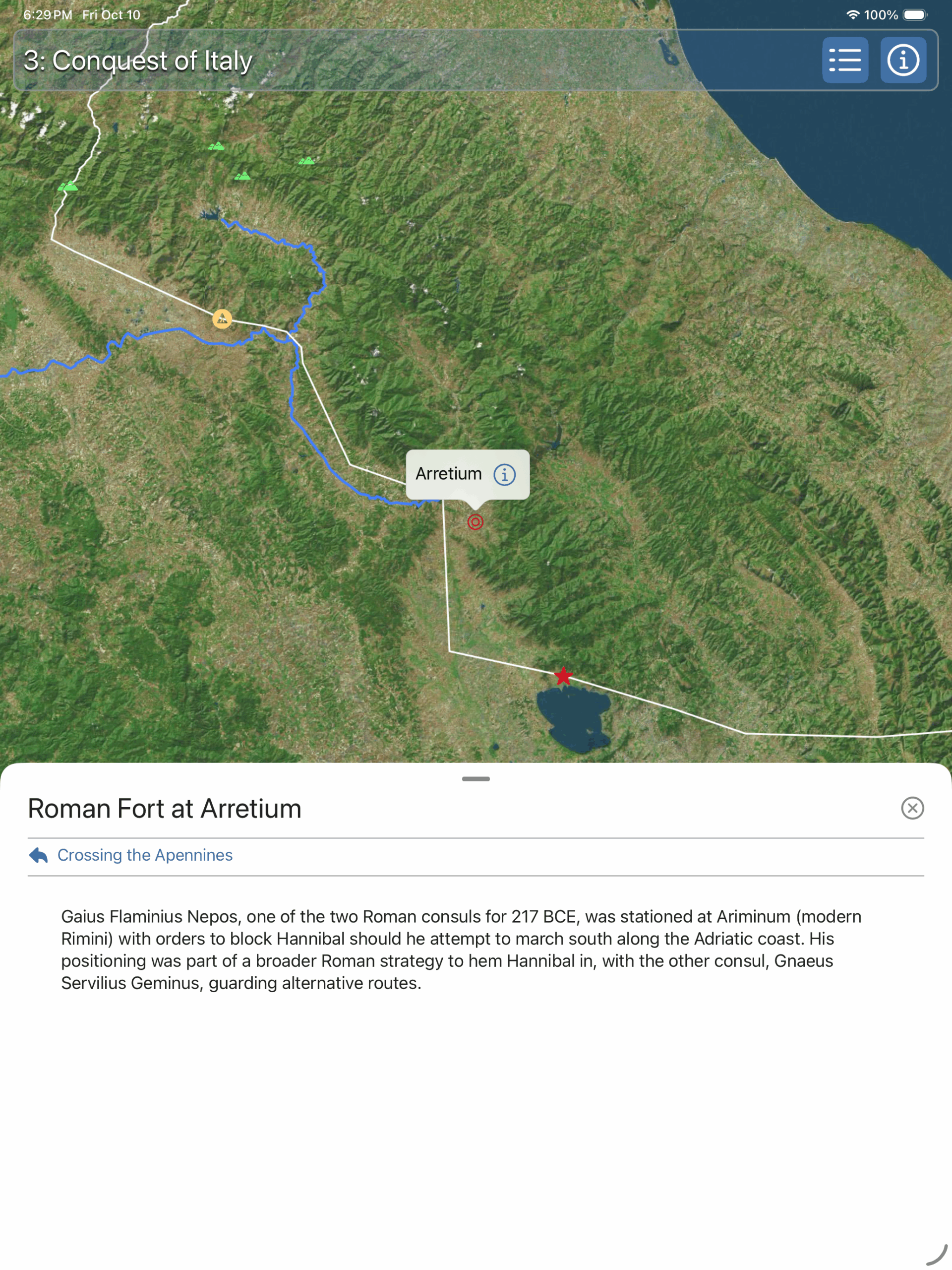
Continuing Journey 3: Conquest of Italy, Figure 4a shows the Collina–Porretta Pass passage, locating a likely route by which Hannibal crossed from the Po Valley into Etruria. When this passage is active, five supporting passages appear: four alternatives to Collina (the Giogo, Futa, Sambuca, and Abetone passes) and the Roman fort at Arretium.
To clarify the landscape, the map adds a polygon (yellow box) outlining the approximate area of the ancient Arno Marsh, which Hannibal’s army crossed under severe hardship. Lines highlight the Arno River, and labels identify these features (Figure 4a).
As with primary passages, you can navigate to a supporting passage directly from the map or via hyperlinks in the narrative text. For example, selecting the Arretium blue hyperlink in Figure 4a opens the supporting passage shown in Figure 4b. Navigation from a supporting passage always returns to its parent passage.
Video
While images help, the best way to grasp how Odyssey Maps works is to see it in motion. The video below dynamically traverses the portion of Journey 3: Conquest of Italy shown above, with map-synced passages and supporting details.
Interested In More?
Hannibal Barca – Rome’s Greatest Enemy is for sale on the Apple App Store for the iPhone, iPad and Mac’s powered by Apple Silica.
Other Odyssey Map apps available on the Apple App Store are:
- Athenian Odyssey – A Unique Guide to Experiencing Ancient Athens, and
- The Athenian Long Walls – A Map-Based Historical Guide
For more information, please visit Odysseymaps.io.
Acknowledgements
Inspiration for the Hannibal app and the Odyssey Maps framework comes from Dr. Patrick Hunt’s Hannibal (Simon & Schuster, 2018) and from insights gained in his Stanford University Continuing Studies courses on Hannibal and Ancient European history. I am grateful for Dr. Hunt’s encouragement and for his permission to draw on course materials and personal photographs for this project.
All images shown in this article were produced in the Hannibal app. © 2025 Odyssey Maps.
Map credits: Map data © 2025 Apple.